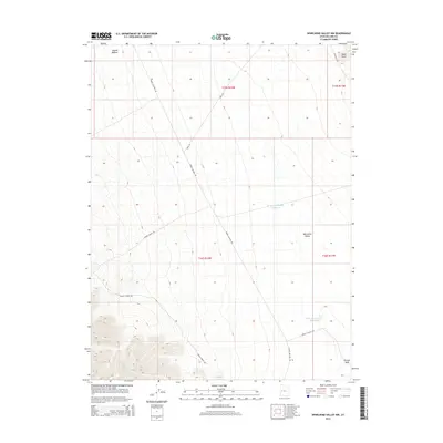
2014 Map of Whirlwind Valley NW
USGS Topo · Published 2014About this map
Whirlwind Valley and the expansive basin of Swasey Bottom anchor this desert landscape in western Millard County. The map documents a network of unpaved access routes essential for livestock and land management, including Swasey Bottom Rd, Swasey Spring Rd, and the Swasey Cutoff Rd. These roads converge near water sources critical to the arid region, such as Swasey Reservoir Number 2 and Swasey Reservoir Number 3. To the northeast, the terrain rises toward the volcanic prominence of Black Point near the N Drum Mt Rd. This 2014 survey reveals the persistent reliance on historic water catchments and trail systems in the Great Basin, where drainage features like Swasey Wash define the movement of both water and travelers across the valley floor.
Find a feature on this map
15 named features on this map. Tap any name to fly to it.
Don’t see what you’re looking for? This feature index may not catch every label — zoom into the map to look around manually.
Map Details
Editions of this 2014 Whirlwind Valley NW Map
This is the sole edition of this map. No revisions or reprints were ever made.
Other maps of this area

1908 · Fish Springs
USGS Topo · 1:250,000

1910 · Fish Springs
USGS Topo · 1:250,000

1953 · Topaz Mtn
USGS Topo · 1:62,500

1953 · Delta
USGS Topo · 1:250,000

1958 · Delta
USGS Topo · 1:250,000

1962 · Delta
USGS Topo · 1:250,000

1967 · Sand Pass SE
USGS Topo · 1:24,000

1972 · Whirlwind Valley SW
USGS Topo · 1:24,000
1972 · Swasey Peak
USGS Topo · 1:24,000
1972 · Little Drum Pass
USGS Topo · 1:24,000