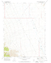
1972 Map of Whirlwind Valley NW
USGS Topo · Published 1974About this map
Swasey Mountain dominates the southwestern corner of this West Central Utah landscape, its high ridges giving way to the expansive alluvial flats of Whirlwind Valley. This 1972 field-checked survey reveals an arid environment defined by seasonal water management and drainage patterns. The ephemeral Swasey Wash cuts through the valley floor, connecting a series of livestock or irrigation improvements including Swasey Res No 2 and Swasey Res No 3. To the north, the terrain transitions into Swasey Bottom, while the isolated volcanic or rocky prominence of Black Point stands as a distinct landmark in the northeast. The map provides a clear look at the public land survey system divisions and the sparsely developed infrastructure characteristic of this high desert region during the early 1970s.
Find a feature on this map
10 named features on this map. Tap any name to fly to it.
Don’t see what you’re looking for? This feature index may not catch every label — zoom into the map to look around manually.
Map Details
Editions of this 1972 Whirlwind Valley NW Map
This is the sole edition of this map. No revisions or reprints were ever made.
Other maps of this area

1908 · Fish Springs
USGS Topo · 1:250,000

1910 · Fish Springs
USGS Topo · 1:250,000

1953 · Topaz Mtn
USGS Topo · 1:62,500

1953 · Delta
USGS Topo · 1:250,000

1958 · Delta
USGS Topo · 1:250,000

1962 · Delta
USGS Topo · 1:250,000

1967 · Sand Pass SE
USGS Topo · 1:24,000

1972 · Whirlwind Valley SW
USGS Topo · 1:24,000
1972 · Swasey Peak
USGS Topo · 1:24,000
1972 · Little Drum Pass
USGS Topo · 1:24,000