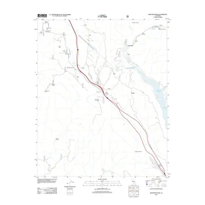
2012 Map of Whitaker Peak
USGS Topo · Published 2012About this map
Whitaker Peak and the surrounding Angeles National Forest terrain are defined by the critical infrastructure and transportation corridors of the 2010s. The Golden State Hwy and the massive Governor Edmund G Brown West Branch California Aqueduct dominate the central landscape, showing the engineering required to move water and traffic through these canyons. Small pockets of settlement like Naylor Place, Martins, and Paradise Ranch contrast with the large-scale utility of the Elderberry Forebay and the northern reaches of Castaic Lake. Recreation remains a primary use of the land, evidenced by Frenchmans Flat Campground, Oak Flat Campground, and the high-elevation Whitaker Peak Lookout. The map provides a look at how historic routes like Ridge Route Rd and The Old Rd weave alongside modern thoroughfares, marking the evolution of travel in this portion of Los Angeles County.
Find a feature on this map
54 named features on this map. Tap any name to fly to it.
Don’t see what you’re looking for? This feature index may not catch every label — zoom into the map to look around manually.
Map Details
Editions of this 2012 Whitaker Peak Map
This is the sole edition of this map. No revisions or reprints were ever made.
Other maps of this area

1900 · Piru
USGS Topo · 1:62,500

1903 · Tejon
USGS Topo · 1:125,000

1903 · Camulos
USGS Topo · 1:125,000

1903 · Santa Susana
USGS Topo · 1:62,500

1921 · Piru
USGS Topo · 1:62,500

1931 · Whitaker Peak
USGS Topo · 1:24,000

1931 · Santa Felicia Canyon
USGS Topo · 1:24,000

1931 · Castaic
USGS Topo · 1:24,000

1931 · Redrock Mtn
USGS Topo · 1:24,000

1932 · Beartrap Canyon
USGS Topo · 1:24,000