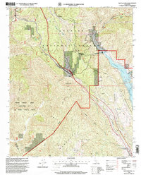
1995 Map of Whitaker Peak
USGS Topo · Published 1999About this map
Piru Creek and its many tributaries, including Cherry Canyon and Osito Canyon, carve through the steep terrain of the Angeles National Forest and Los Padres National Forest. This 1995 revision documents the sophisticated water management and energy infrastructure of the region, featuring the Castaic Powerplant and the massive Elderberry Forebay and Castaic Lake complex. The landscape is a study in transit history, showing the winding path of the Old Ridge Route contrasted with the more modern Golden State Highway slicing through Violin Summit. Small outposts like Paradise Ranch, Oak Flat Sta, and the Beacon Forest Inn provide evidence of early mountain commerce and forestry management along these vital canyon corridors. The map also highlights recreational and educational spaces such as Camp Verdugo Oaks and the Castaic Lake State Recreation Area.
Find a feature on this map
57 named features on this map. Tap any name to fly to it.
Don’t see what you’re looking for? This feature index may not catch every label — zoom into the map to look around manually.
Map Details
Editions of this 1995 Whitaker Peak Map
This is the sole edition of this map. No revisions or reprints were ever made.
Other maps of this area

1900 · Piru
USGS Topo · 1:62,500

1903 · Tejon
USGS Topo · 1:125,000

1903 · Camulos
USGS Topo · 1:125,000

1903 · Santa Susana
USGS Topo · 1:62,500

1921 · Piru
USGS Topo · 1:62,500

1931 · Whitaker Peak
USGS Topo · 1:24,000

1931 · Santa Felicia Canyon
USGS Topo · 1:24,000

1931 · Castaic
USGS Topo · 1:24,000

1931 · Redrock Mtn
USGS Topo · 1:24,000

1932 · Beartrap Canyon
USGS Topo · 1:24,000