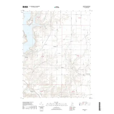
2019 Map of Whitcomb
USGS Topo · Published 2019About this map
Brookville Lake dominates the northwest corner of this Franklin County landscape, its western shores marked by significant cultural landmarks like The Mounds and the historical site of Battle Point. The map details a transition from the structured recreational spaces of the lake to the deeply dissected valley of the Whitewater River and its numerous tributaries, including Little Cedar Cr and Richland Cr. Small, established communities like Whitcomb, Palestine, and Mount Carmel anchor the road network, which is defined by long-standing routes like Oxford Pike and Liberty Pike. The terrain is characterized by named elevations such as Garr Hill and Bon Well Hill, while the local history is preserved in the location of the James Cem and Mount Carmel Cem. This topography reflects the typical settlement patterns of southeast Indiana, where development follows the winding ridges and narrow hollows like Sleepy Hollow and Owl Hollow.
Find a feature on this map
76 named features on this map. Tap any name to fly to it.
Don’t see what you’re looking for? This feature index may not catch every label — zoom into the map to look around manually.
Map Details
Editions of this 2019 Whitcomb Map
This is the sole edition of this map. No revisions or reprints were ever made.
Other maps of this area

1915 · College Corner
USGS Topo · 1:48,000

1915 · Harrison
USGS Topo · 1:48,000

1918 · College Corner
USGS Topo · 1:62,500

1948 · Fairfield
USGS Topo · 1:24,000

1953 · Cincinnati
USGS Topo · 1:250,000

1955 · Harrison
USGS Topo · 1:24,000

1955 · Reily
USGS Topo · 1:24,000

1955 · Mount Carmel
USGS Topo · 1:24,000
1955 · Cedar Grove
USGS Topo · 1:24,000

1956 · Everton
USGS Topo · 1:24,000