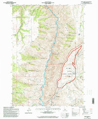
1995 Map of White Bird
USGS Topo · Published 1999About this map
The Salmon River cuts a deep path through Idaho’s interior, defining the rugged geography of the Nez Perce National Historical Park. This terrain is deeply marked by the history of the 1877 conflict, with the Battle Ground clearly identified alongside the Nez Perce Indian War Historical Monument and the Nez Perce Indian War Interpretive Site. These landmarks provide crucial context for the events that unfolded along the steep slopes of White Bird Hill and the surrounding canyons.
Find a feature on this map
56 named features on this map. Tap any name to fly to it.
Don’t see what you’re looking for? This feature index may not catch every label — zoom into the map to look around manually.
Map Details
Editions of this 1995 White Bird Map
This is the sole edition of this map. No revisions or reprints were ever made.
Other maps of this area

1955 · Grangeville
USGS Topo · 1:250,000

1959 · Grangeville
USGS Topo · 1:250,000

1963 · McKinzie Creek
USGS Topo · 1:24,000

1963 · Grangeville West
USGS Topo · 1:24,000

1963 · White Bird Hill
USGS Topo · 1:24,000

1963 · Slate Creek
USGS Topo · 1:24,000

1963 · Moughmer Point
USGS Topo · 1:24,000

1963 · Joseph
USGS Topo · 1:24,000

1963 · Grave Point
USGS Topo · 1:24,000

1963 · White Bird
USGS Topo · 1:24,000