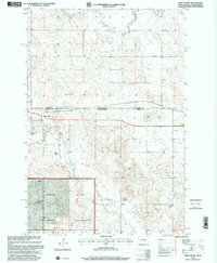
1998 Map of White Butte
USGS Topo · Published 2001About this map
The Grand River National Grassland dominates the southern landscape of this 1998 survey, situated along the border of North Dakota and South Dakota. This region is defined by its agricultural legacy and sparse prairie settlements, including White Butte and Petrel. The map details a network of family-held lands such as the B Anderson Ranch, F Fogerty Ranch, and Hoffman Ranch, illustrating the vast ranching operations characteristic of Perkins County. In the north, the Seventh Standard Parallel North serves as a critical surveying line, while the Petrel Cem and a Townhall mark the community centers of this rural territory. Water resources are managed via the White Butte Reservoir and Flat Creek, supporting both the local livestock and the Grand River Grazing Work Facility.
Find a feature on this map
22 named features on this map. Tap any name to fly to it.
Don’t see what you’re looking for? This feature index may not catch every label — zoom into the map to look around manually.
Map Details
Editions of this 1998 White Butte Map
This is the sole edition of this map. No revisions or reprints were ever made.
Other maps of this area

1953 · Dickinson
USGS Topo · 1:250,000

1954 · Lemmon
USGS Topo · 1:250,000

1957 · Dickinson
USGS Topo · 1:250,000

1957 · Lemmon
USGS Topo · 1:250,000

1974 · Cedar Butte
USGS Topo · 1:24,000

1974 · White Butte
USGS Topo · 1:24,000

1974 · Lemmon
USGS Topo · 1:24,000

1974 · Haynes
USGS Topo · 1:24,000

1980 · Mott
USGS Topo · 1:100,000

1983 · Haynes SE
USGS Topo · 1:24,000