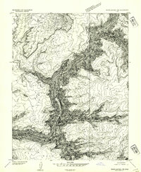
1954 Map of White Canyon 1 NW
USGS Topo · Published 1954About this map
The Colorado River carves a deep, winding path through the canyonlands of southern Utah in this 1952 survey, published as a preliminary edition in 1954. The landscape is defined by massive topographic features like the elevated Dry Mesa and the prominent Middle Point peninsula. This map captures the region just before the completion of Glen Canyon Dam downstream would fundamentally alter the river's profile and character. Rare water sources in this arid environment are carefully noted, including Cove Spring and the curiously named Freddies Cistern. Along the western edge, the border between Garfield Co and San Juan Co follows the jagged rim of the canyon, illustrating how the natural geology of Black Ledge and Bowdie dictated political boundaries and land management in the mid-20th century.
Find a feature on this map
9 named features on this map. Tap any name to fly to it.
Don’t see what you’re looking for? This feature index may not catch every label — zoom into the map to look around manually.
Map Details
Editions of this 1954 White Canyon 1 NW Map
This is the sole edition of this map. No revisions or reprints were ever made.
Other maps of this area

1885 · San Rafael
USGS Topo · 1:250,000

1886 · Henry Mountains
USGS Topo · 1:250,000

1892 · Henry Mountains
USGS Topo · 1:250,000

1952 · Mouth of Dark Canyon
USGS Topo · 1:62,500

1952 · Hite
USGS Topo · 1:62,500

1953 · Orange Cliffs 3 SE
USGS Topo · 1:24,000

1953 · Orange Cliffs 4 SW
USGS Topo · 1:24,000

1953 · Fiddler Butte
USGS Topo · 1:62,500

1953 · Orange Cliffs
USGS Topo · 1:62,500
1954 · White Canyon 1 NE
USGS Topo · 1:24,000