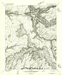
1954 Map of White Canyon 1 SW
USGS Topo · Published 1954About this map
The high mesas and deeply incised canyons of San Juan County are captured here in a 1952 survey by the U.S. Geological Survey. This preliminary edition, derived from 1951 aerial photography, focuses on the elevation changes across landforms like Dry Mesa and Black Point. The map provides a look at the landscape's natural drainage and catchment points, exemplified by a single Reservoir located just below the northern rim of Short Canyon. The terrain is characterized by dramatic escarpments and plateau surfaces, including the expansive Lean-To Point in the northeast and Lower Horse Flats to the east. Navigational landmarks like Indian Head serve as prominent points of orientation in a region defined by its complex topographic relief and isolated high-desert plateaus.
Find a feature on this map
7 named features on this map. Tap any name to fly to it.
Don’t see what you’re looking for? This feature index may not catch every label — zoom into the map to look around manually.
Map Details
Editions of this 1954 White Canyon 1 SW Map
This is the sole edition of this map. No revisions or reprints were ever made.
Other maps of this area

1886 · Henry Mountains
USGS Topo · 1:250,000

1892 · Henry Mountains
USGS Topo · 1:250,000

1952 · Mouth of Dark Canyon
USGS Topo · 1:62,500

1952 · Mancos Mesa
USGS Topo · 1:62,500

1952 · Natural Bridges
USGS Topo · 1:62,500

1952 · Hite
USGS Topo · 1:62,500
1954 · White Canyon 1 NE
USGS Topo · 1:24,000

1954 · White Canyon 4 NE
USGS Topo · 1:24,000
1954 · White Canyon 1 SE
USGS Topo · 1:24,000
1954 · White Canyon 2 NE
USGS Topo · 1:24,000