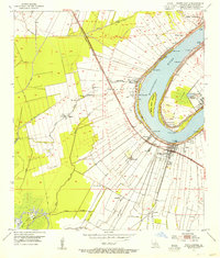
1953 Map of White Castle
USGS Topo · Published 1955About this map
Sugar cane fields and river landings define this riverfront landscape in Iberville Parish during the early 1950s. The Mississippi River creates a sharp bend around Point, where the National Leprosarium stands as a prominent landmark. Along the western bank, the town of White Castle serves as a hub for the Texas and Pacific railroad, connecting surrounding agricultural communities like Glenmore, Tally Ho, and Augusta. The survey reveals a dense network of water-based infrastructure, from the Bayou Goula Landing to the White Castle Oil Field Bayou in the south.
Find a feature on this map
45 named features on this map. Tap any name to fly to it.
Don’t see what you’re looking for? This feature index may not catch every label — zoom into the map to look around manually.
Map Details
Editions of this 1953 White Castle Map
2 editions found
Other maps of this area

1908 · Baton Rouge
USGS Topo · 1:62,500

1935 · Chicot Lake
USGS Topo · 1:62,500

1936 · White Castle
USGS Topo · 1:62,500

1939 · Baton Rouge
USGS Topo · 1:62,500

1940 · Grosse Tete
USGS Topo · 1:62,500

1953 · Crescent
USGS Topo · 1:24,000

1953 · Plaquemine
USGS Topo · 1:24,000

1953 · Addis
USGS Topo · 1:24,000

1953 · St. Gabriel
USGS Topo · 1:24,000
1953 · Carville
USGS Topo · 1:24,000