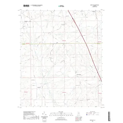
2020 Map of White City
USGS Topo · Published 2020About this map
Enterprise and White City anchor this landscape along the border of Chilton and Autauga Counties. The area is defined by a dense network of county roads and numerous small family or community burial grounds, such as Pleasant Valley Cem, Bethany Cem, and Floyd Cem. The terrain is deeply carved by watercourses including Sandy Cr, Clear Cr, and Mortar Cr, which drain the rolling woodlands and small agricultural clearings. The presence of New Lily Hill Cem and New Prospect Cem indicates established rural communities that have long centered their social and spiritual lives around these high points and creek valleys. Further south, White Spring and the settlement of New Prospect illustrate the persistent pattern of small-scale rural development that characterizes this central Alabama region, where local landmarks like Sunny Hill Cem continue to serve as vital genealogical touchstones.
Find a feature on this map
90 named features on this map. Tap any name to fly to it.
Don’t see what you’re looking for? This feature index may not catch every label — zoom into the map to look around manually.
Map Details
Editions of this 2020 White City Map
This is the sole edition of this map. No revisions or reprints were ever made.
Other maps of this area

1891 · Clanton
USGS Topo · 1:125,000

1901 · Wetumpka
USGS Topo · 1:125,000

1903 · Wetumpka
USGS Topo · 1:125,000

1953 · Montgomery
USGS Topo · 1:250,000

1956 · Montgomery
USGS Topo · 1:250,000

1957 · Montgomery
USGS Topo · 1:250,000

1959 · Billingsley
USGS Topo · 1:62,500

1959 · Elmore
USGS Topo · 1:62,500
1971 · Mitchell Dam
USGS Topo · 1:24,000
1972 · Clanton West
USGS Topo · 1:24,000