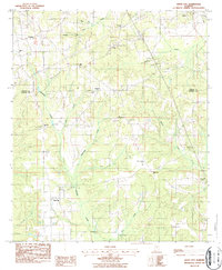
1987 Map of White City
USGS Topo · Published 1987About this map
White City and the surrounding rural landscape of the Chilton and Autauga county line are documented in this 1980s-era study. The terrain is defined by a dense network of tributaries including Little Autauga Creek, McKensey Creek, and Mortar Creek, which carve through the wooded hills. Small rural settlements like Enterprise and the southern edge of Verbena are connected by a web of unimproved roads and the CSX railroad line in the northeast.
Find a feature on this map
29 named features on this map. Tap any name to fly to it.
Don’t see what you’re looking for? This feature index may not catch every label — zoom into the map to look around manually.
Map Details
Editions of this 1987 White City Map
This is the sole edition of this map. No revisions or reprints were ever made.
Other maps of this area

1891 · Clanton
USGS Topo · 1:125,000

1901 · Wetumpka
USGS Topo · 1:125,000

1903 · Wetumpka
USGS Topo · 1:125,000

1953 · Montgomery
USGS Topo · 1:250,000

1956 · Montgomery
USGS Topo · 1:250,000

1957 · Montgomery
USGS Topo · 1:250,000

1959 · Billingsley
USGS Topo · 1:62,500

1959 · Elmore
USGS Topo · 1:62,500
1971 · Mitchell Dam
USGS Topo · 1:24,000
1972 · Clanton West
USGS Topo · 1:24,000