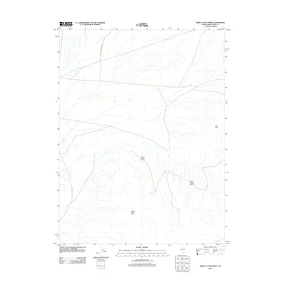
2012 Map of White Cloud Point
USGS Topo · Published 2012About this map
White Cloud Point stands as the primary landmark in this high-desert landscape of White Pine County, where the terrain shifts from alluvial plains into the foothills of the Little Hills. The drainage patterns are defined by seasonal watercourses like Mike Springs Wash and Indian George Wash, which carve through the arid basin floor. Local access through this segment of the Great Basin is provided by primitive routes such as Grass Valley Canyon Rd and Co Rd 37, reflecting the sparse infrastructure typical of this ranching and mining region. The intricate topography of White Cloud Basin and the steep walls of White Cloud Canyon dominate the southern portion of the map, illustrating the erosional forces that have shaped the Nevada interior.
Find a feature on this map
8 named features on this map. Tap any name to fly to it.
Don’t see what you’re looking for? This feature index may not catch every label — zoom into the map to look around manually.
Map Details
Editions of this 2012 White Cloud Point Map
This is the sole edition of this map. No revisions or reprints were ever made.
Other maps of this area

1956 · Ely
USGS Topo · 1:250,000

1959 · Ely
USGS Topo · 1:250,000

1963 · Ely
USGS Topo · 1:250,000
1986 · Third Butte West
USGS Topo · 1:24,000
1986 · Big Hard Pan
USGS Topo · 1:24,000
1986 · Mormon Jack Pass
USGS Topo · 1:24,000
1986 · Tippett Pass
USGS Topo · 1:24,000
1986 · Grass Valley Wash
USGS Topo · 1:24,000
1986 · White Cloud Point
USGS Topo · 1:24,000
1986 · Third Butte East
USGS Topo · 1:24,000