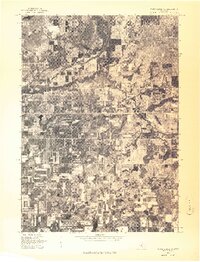
1976 Map of White Cloud SW
USGS Topo · Published 1976About this map
Aetna sits at the heart of this mid-1970s orthophotoquad, which captures the shifting patterns of Newaygo County land use through direct aerial imagery. The landscape is defined by a dense mosaic of agricultural fields and woodlots, revealing the intricate boundary lines between cleared farmland and natural vegetation. A prominent meandering river system cuts through the northern half of the sheet, its tight oxbows and riparian wetlands creating a stark contrast to the rigid, gridded geometry of the surrounding section lines and rural roads. This photographic record captures the precise state of the terrain just before the close of the decade, documenting the density of forest cover and the specific footprint of the local settlement and farmsteads.
Find a feature on this map
1 named feature on this map. Tap any name to fly to it.
Don’t see what you’re looking for? This feature index may not catch every label — zoom into the map to look around manually.
Map Details
Editions of this 1976 White Cloud SW Map
This is the sole edition of this map. No revisions or reprints were ever made.
Other maps of this area

1931 · Walkerville NE
USGS Topo · 1:31,680

1931 · Walkerville SE
USGS Topo · 1:31,680

1954 · Milwaukee
USGS Topo · 1:250,000

1954 · Midland
USGS Topo · 1:250,000

1958 · Midland
USGS Topo · 1:250,000

1958 · Milwaukee
USGS Topo · 1:250,000

1958 · Hesperia
USGS Topo · 1:62,500

1958 · Twin Lake
USGS Topo · 1:62,500

1958 · Fremont
USGS Topo · 1:62,500

1959 · Midland
USGS Topo · 1:250,000