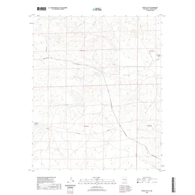
2020 Map of White Flat SE
USGS Topo · Published 2020About this map
Middle Arroyo and Salt Cr carve through this high-desert landscape in Chaves County, revealing a network of drainage patterns and land-use markers from the early twenty-first century. The map depicts a transition from upland features like Blackwater Hill to the etched depths of Chimney Canyon and Rock House Canyon. Human passage through this arid terrain is defined by a sparse but vital road network, including the diagonal crossing of W Pine Lodge Rd and the more remote Draper Rd. These routes, along with cattle-country markers such as Brown Lake Rd, indicate the ranching-driven economy of the region. The map also illustrates the precise Public Land Survey System boundaries, specifically the intersection of Township 8 South and Township 9 South across Ranges 21 and 22 East, grounding the topographic features in a clear legal and historical grid.
Find a feature on this map
16 named features on this map. Tap any name to fly to it.
Don’t see what you’re looking for? This feature index may not catch every label — zoom into the map to look around manually.
Map Details
Editions of this 2020 White Flat SE Map
This is the sole edition of this map. No revisions or reprints were ever made.
Other maps of this area

1949 · Corn Ranch
USGS Topo · 1:24,000

1950 · Corn Ranch
USGS Topo · 1:24,000

1955 · Roswell
USGS Topo · 1:250,000

1958 · Roswell
USGS Topo · 1:250,000

1962 · Roswell
USGS Topo · 1:250,000

1962 · Horseshoe Bend
USGS Topo · 1:62,500

1962 · Rock House Canyon
USGS Topo · 1:24,000
1963 · Barn Draw
USGS Topo · 1:24,000

1967 · White Flat
USGS Topo · 1:24,000
1967 · White Flat SE
USGS Topo · 1:24,000