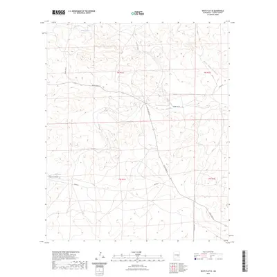
2023 Map of White Flat SE
USGS Topo · Published 2023About this map
Middle Arroyo and Salt Creek carve through the high plains of Chaves County, defining a landscape of drainage networks and subtle topographic relief. This modern survey illustrates the current connectivity of rural New Mexico, where arterial routes like W Pine Lodge Rd and Brown Lake Rd intersect the vast Public Land Survey System grids of t8s r21e and t9s r21e. The map reveals the intricate geography of the region's dry canyons, including Rock Tank Canyon in the northeast and Chimney Canyon to the southwest. Local movement is dictated by a web of established roads such as Draper Rd, Lake Spur Rd, and Verbena Rd, which provide access across the sprawling ranchlands and arroyos that characterize this part of the state.
Find a feature on this map
15 named features on this map. Tap any name to fly to it.
Don’t see what you’re looking for? This feature index may not catch every label — zoom into the map to look around manually.
Map Details
Editions of this 2023 White Flat SE Map
This is the sole edition of this map. No revisions or reprints were ever made.
Other maps of this area

1949 · Corn Ranch
USGS Topo · 1:24,000

1950 · Corn Ranch
USGS Topo · 1:24,000

1955 · Roswell
USGS Topo · 1:250,000

1958 · Roswell
USGS Topo · 1:250,000

1962 · Roswell
USGS Topo · 1:250,000

1962 · Horseshoe Bend
USGS Topo · 1:62,500

1962 · Rock House Canyon
USGS Topo · 1:24,000
1963 · Barn Draw
USGS Topo · 1:24,000

1967 · White Flat
USGS Topo · 1:24,000
1967 · White Flat SE
USGS Topo · 1:24,000