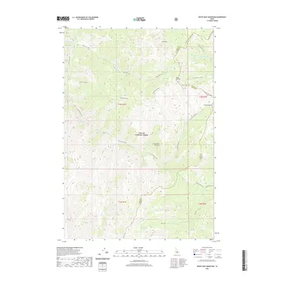
2020 Map of White Goat Mountain
USGS Topo · Published 2020About this map
The high peaks of the Salmon River Mountains dominate this high-altitude landscape within Challis National Forest. Situated along the boundary of Lemhi County and Custer County, the terrain is defined by dramatic ridgelines such as White Goat Ridge and prominent summits including White Mtn and White Goat Mtn. This 2020 survey illustrates a complex hydrologic network of alpine basins, where White Goat Lake, Eddy Lake, and the West Fork Lakes feed a series of descending drainages. The map traces the headwaters of White Goat Creek and Camas-Eddy Creek, showing how these waters navigate the steep topography. Features like Camas Meadows and Camas Meadow provide evidence of the few relatively level openings amidst the high-country peaks and ridges.
Find a feature on this map
26 named features on this map. Tap any name to fly to it.
Don’t see what you’re looking for? This feature index may not catch every label — zoom into the map to look around manually.
Map Details
Editions of this 2020 White Goat Mountain Map
This is the sole edition of this map. No revisions or reprints were ever made.
Other maps of this area

1930 · Casto
USGS Topo · 1:125,000

1956 · Twin Peaks
USGS Topo · 1:62,500

1957 · Challis
USGS Topo · 1:250,000

1960 · Challis
USGS Topo · 1:250,000

1963 · Challis
USGS Topo · 1:250,000

1963 · Challis Creek Lakes
USGS Topo · 1:24,000

1963 · Meyers Cove
USGS Topo · 1:24,000
1963 · Sheldon Peak
USGS Topo · 1:24,000
1963 · Black Mtn
USGS Topo · 1:24,000
1963 · Meyers Cove Point
USGS Topo · 1:24,000