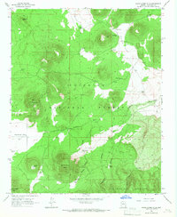
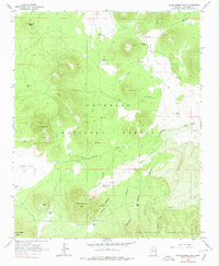
1966 Map of White Horse Hills
USGS Topo · Published 1968About this map
White Horse Hills and the adjacent Coconino National Forest define this volcanic landscape in the mid-1960s. The terrain is characterized by a sophisticated network of water management features essential for ranching and forest operations, including numerous named livestock tanks such as Bonita Tank, Indian Tank, and McKinney Tank. The map reveals the functional layout of the high-elevation flats and basins, with a notable Landing Strip and Well situated in Kendrick Park, while deep topographic incisions like Abineau Canyon and Bear Canyon descend toward the southern edge of the sheet. The presence of Saddle Mtn and Maverick Butte alongside various cinder pits indicates the region's geologic origins, providing a detailed record of the forest's development before modern expansion. This survey effectively documents the intersection of natural volcanic formations and the infrastructure of the San Francisco Mountain area.
Find a feature on this map
39 named features on this map. Tap any name to fly to it.
Don’t see what you’re looking for? This feature index may not catch every label — zoom into the map to look around manually.
Map Details
Editions of this 1966 White Horse Hills Map
5 editions found
Other maps of this area

1886 · San Francisco Mtns
USGS Topo · 1:250,000

1891 · San Francisco Mtns
USGS Topo · 1:250,000

1894 · San Francisco Mtns
USGS Topo · 1:250,000

1899 · San Francisco Mtns
USGS Topo · 1:250,000

1908 · Flagstaff
USGS Topo · 1:125,000

1912 · Flagstaff
USGS Topo · 1:125,000

1947 · Flagstaff
USGS Topo · 1:250,000

1954 · Flagstaff
USGS Topo · 1:250,000

1958 · Flagstaff
USGS Topo · 1:250,000

1960 · Flagstaff
USGS Topo · 1:250,000