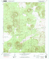
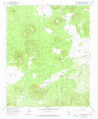
1966 Map of White Horse Hills
USGS Topo · Published 1978About this map
Coconino National Forest encompasses this high-altitude landscape of northern Arizona, dominated by the volcanic forms of the White Horse Hills and Saddle Mtn. The 1966 field survey reveals a terrain managed for multiple uses, where a solitary Lookout Tower stands watch over the timber while a Cinder Pit indicates local mineral extraction. A notable pattern of livestock and wildlife management is evident through the naming of numerous water catchments, such as Reese Tanks, Potato Tank, and the numbered Tub No. 2 and Tub No. 3 stations.
Find a feature on this map
48 named features on this map. Tap any name to fly to it.
Don’t see what you’re looking for? This feature index may not catch every label — zoom into the map to look around manually.
Map Details
Editions of this 1966 White Horse Hills Map
5 editions found
Other maps of this area

1886 · San Francisco Mtns
USGS Topo · 1:250,000

1891 · San Francisco Mtns
USGS Topo · 1:250,000

1894 · San Francisco Mtns
USGS Topo · 1:250,000

1899 · San Francisco Mtns
USGS Topo · 1:250,000

1908 · Flagstaff
USGS Topo · 1:125,000

1912 · Flagstaff
USGS Topo · 1:125,000

1947 · Flagstaff
USGS Topo · 1:250,000

1954 · Flagstaff
USGS Topo · 1:250,000

1958 · Flagstaff
USGS Topo · 1:250,000

1960 · Flagstaff
USGS Topo · 1:250,000