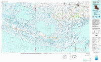
1983 Map of White Lake
USGS Topo · Published 1983About this map
White Lake and the vast marshlands of the Vermilion Parish coast define this 1983 survey. This map highlights a complex hydrographic landscape where the Intracoastal Waterway and numerous man-made channels like the Freshwater Bayou Canal and Leland Bowman Canal intersect with natural features such as the Mermentau River and Grand Lake. Settlement is concentrated along the northern corridor and higher ground ridges, with Abbeville and Kaplan serving as primary hubs. The Southern Pacific railroad line is visible connecting the agricultural and industrial centers of the region.
Find a feature on this map
104 named features on this map. Tap any name to fly to it.
Don’t see what you’re looking for? This feature index may not catch every label — zoom into the map to look around manually.
Map Details
Editions of this 1983 White Lake Map
2 editions found
Other maps of this area

1932 · Abbeville SW
USGS Topo · 1:31,680

1932 · Constance Bayou NE
USGS Topo · 1:31,680

1932 · Abbeville SE
USGS Topo · 1:31,680

1932 · Abbeville NE
USGS Topo · 1:31,680

1932 · Pecan Island SE
USGS Topo · 1:31,680

1932 · Constance Bayou SW
USGS Topo · 1:31,680

1932 · Abbeville NW
USGS Topo · 1:31,680

1932 · Pecan Island SW
USGS Topo · 1:31,680

1932 · Lake Charles SE
USGS Topo · 1:31,680

1932 · Constance Bayou SE
USGS Topo · 1:31,680