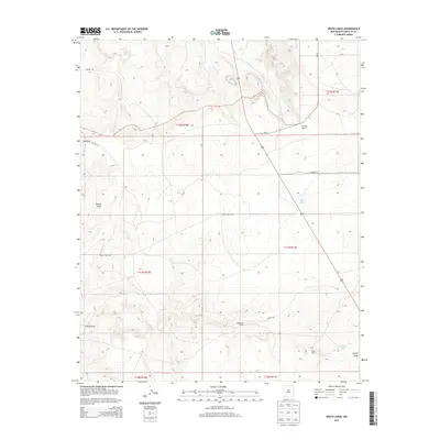
2013 Map of White Lakes
USGS Topo · Published 2013About this map
Hagerman Ranch and Snow Ranch anchor this landscape in Santa Fe County, representing the persistent ranching legacy of the high desert. This 2013 survey by the U.S. Geological Survey illustrates a sparsely populated region defined by drainage networks like Arroyo Jara, Kinsell Draw, and Armijo Draw. The namesake White Lakes and artificial water sources such as Spring Tank reveal how vital water management is for agricultural operations in this arid environment. Transportation is limited to functional routes including the aptly named Rough Rd and White Lakes Rd, which traverse the section lines of the Public Land Survey System. The map provides a clear look at the intersection of private ranch land and the expansive open terrain east of the Rio Grande valley.
Find a feature on this map
19 named features on this map. Tap any name to fly to it.
Don’t see what you’re looking for? This feature index may not catch every label — zoom into the map to look around manually.
Map Details
Editions of this 2013 White Lakes Map
This is the sole edition of this map. No revisions or reprints were ever made.
Other maps of this area

1894 · Lamy
USGS Topo · 1:125,000

1954 · Santa Fe
USGS Topo · 1:250,000

1958 · Santa Fe
USGS Topo · 1:250,000

1960 · Stanley
USGS Topo · 1:62,500
1966 · Mesa El Toro
USGS Topo · 1:24,000
1966 · Clines Corners
USGS Topo · 1:24,000
1966 · Ojo Hedionda
USGS Topo · 1:24,000
1966 · Rencona
USGS Topo · 1:24,000
1966 · Wildhorse Mesa
USGS Topo · 1:24,000
1983 · Villanueva
USGS Topo · 1:100,000