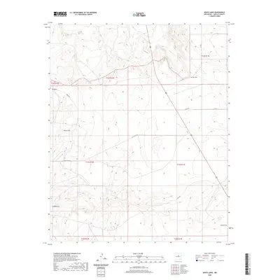
2020 Map of White Lakes
USGS Topo · Published 2020About this map
High desert drainage patterns and ranching infrastructure define this landscape in Santa Fe County, where ephemeral watercourses like Arroyo Jara and Big Draw carve through the terrain. The presence of Spring Tank in the southeast corner indicates the critical importance of water management in this arid region of New Mexico. The map reveals a systematic grid of land management, bounded by townships such as t12n r11e and t11n r10e, which organizes the territory for agricultural or grazing use. Human transit across this open country is facilitated by a network of local thoroughfares, including White Lakes Rd and several county routes like Co Rd 16B, while highway 285 provides a primary north-south artery through the hills. This survey documents the intersection of natural topographical features like Kinsell Draw with the modern administrative and transport systems of the high plains.
Find a feature on this map
16 named features on this map. Tap any name to fly to it.
Don’t see what you’re looking for? This feature index may not catch every label — zoom into the map to look around manually.
Map Details
Editions of this 2020 White Lakes Map
This is the sole edition of this map. No revisions or reprints were ever made.
Other maps of this area

1894 · Lamy
USGS Topo · 1:125,000

1954 · Santa Fe
USGS Topo · 1:250,000

1958 · Santa Fe
USGS Topo · 1:250,000

1960 · Stanley
USGS Topo · 1:62,500
1966 · Mesa El Toro
USGS Topo · 1:24,000
1966 · Clines Corners
USGS Topo · 1:24,000
1966 · Ojo Hedionda
USGS Topo · 1:24,000
1966 · Rencona
USGS Topo · 1:24,000
1966 · Wildhorse Mesa
USGS Topo · 1:24,000
1983 · Villanueva
USGS Topo · 1:100,000