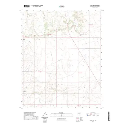
2023 Map of White Lakes
USGS Topo · Published 2023About this map
Arroyo Jara and its seasonal drainages define this stretch of Santa Fe County, where the topography of the High Plains meets the intermittent watercourses of the desert southwest. This modern survey illustrates the persistent ranching and transportation infrastructure that characterizes the region, centered on the White Lakes Rd corridor. Named landmarks like Big Draw, Kinsell Draw, and Armijo Draw reveal how natural erosion patterns have shaped local navigation and land use for generations. The landscape is sparse, marked primarily by isolated water features such as Spring Tank and a network of secondary routes including Rough Rd and Co Rd 34. These features provide a clear view of the rural township and range system, showing the enduring spatial organization of this part of New Mexico into the early twenty-first century.
Find a feature on this map
16 named features on this map. Tap any name to fly to it.
Don’t see what you’re looking for? This feature index may not catch every label — zoom into the map to look around manually.
Map Details
Editions of this 2023 White Lakes Map
This is the sole edition of this map. No revisions or reprints were ever made.
Other maps of this area

1894 · Lamy
USGS Topo · 1:125,000

1954 · Santa Fe
USGS Topo · 1:250,000

1958 · Santa Fe
USGS Topo · 1:250,000

1960 · Stanley
USGS Topo · 1:62,500
1966 · Mesa El Toro
USGS Topo · 1:24,000
1966 · Clines Corners
USGS Topo · 1:24,000
1966 · Ojo Hedionda
USGS Topo · 1:24,000
1966 · Rencona
USGS Topo · 1:24,000
1966 · Wildhorse Mesa
USGS Topo · 1:24,000
1983 · Villanueva
USGS Topo · 1:100,000