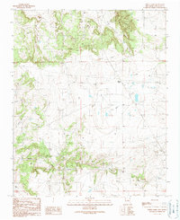
1990 Map of White Lakes
USGS Topo · Published 1990About this map
The high plains of Santa Fe County are defined here by the seasonal basins of the White Lakes and the rugged drainage systems that carve through the arid terrain. This 1990 provisional survey documents a landscape of ranching and utility infrastructure, where water sources like Bozier Well, Spring Tank, and several labeled Water Tanks are essential markers of human presence. The topography is shaped by the San Cristoval highlands and deep-cut channels such as Armijo Draw, Kinsell Draw, and the Arroyo de la Jara. Evidence of remote activity is visible in the isolated Landing Strip, various 4wd tracks, and a prominent Trans Line that cuts across the southern sections of the quadrangle, reflecting the modern utility of this expansive New Mexican territory.
Find a feature on this map
17 named features on this map. Tap any name to fly to it.
Don’t see what you’re looking for? This feature index may not catch every label — zoom into the map to look around manually.
Map Details
Editions of this 1990 White Lakes Map
This is the sole edition of this map. No revisions or reprints were ever made.
Other maps of this area

1894 · Lamy
USGS Topo · 1:125,000

1954 · Santa Fe
USGS Topo · 1:250,000

1958 · Santa Fe
USGS Topo · 1:250,000

1960 · Stanley
USGS Topo · 1:62,500
1966 · Mesa El Toro
USGS Topo · 1:24,000
1966 · Clines Corners
USGS Topo · 1:24,000
1966 · Ojo Hedionda
USGS Topo · 1:24,000
1966 · Rencona
USGS Topo · 1:24,000
1966 · Wildhorse Mesa
USGS Topo · 1:24,000
1983 · Villanueva
USGS Topo · 1:100,000