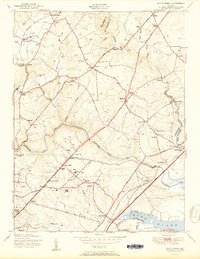
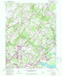
1951 Map of White Marsh
USGS Topo · Published 1951About this map
The Gunpowder Falls and Little Gunpowder Falls define the drainage and the boundary between Baltimore and Harford counties, carving through a landscape of rolling hills and agricultural settlements. In the early 1950s, this region shows a transition from rural crossroads like Fork and Kingsville to emerging suburban nodes along the General Pulaski Highway and Bel Air Road. Small farming clusters such as Gittings and Jerusalem are anchored by local institutions like Fork Church and St Stephens Church, while the presence of numerous greenhouses suggests a thriving local horticultural industry. The rail infrastructure is well-established, with the Baltimore and Ohio Railroad serving White Marsh Station and Bradshaw, while the Pennsylvania line reaches northern points like Baldwin Station. This survey captures the area just as the expansion of the Baltimore metropolitan region began to accelerate, visible in the cluster of homes at Perry Hall and the vicinity of Perry Hall School.
Find a feature on this map
63 named features on this map. Tap any name to fly to it.
Don’t see what you’re looking for? This feature index may not catch every label — zoom into the map to look around manually.
Map Details
Editions of this 1951 White Marsh Map
6 editions found

Other maps of this area

1893 · Gunpowder
USGS Topo · 1:62,500

1894 · Baltimore
USGS Topo · 1:62,500

1898 · Tolchester
USGS Topo · 1:125,000

1899 · Baltimore
USGS Topo · 1:62,500

1900 · Parkton
USGS Topo · 1:62,500

1901 · Belair
USGS Topo · 1:62,500

1901 · Gunpowder
USGS Topo · 1:62,500

1902 · Parkton
USGS Topo · 1:62,500

1903 · Tolchester
USGS Topo · 1:125,000

1904 · Baltimore
USGS Topo · 1:62,500