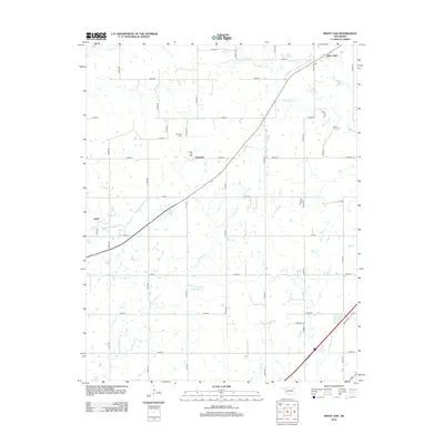
2012 Map of White Oak
USGS Topo · Published 2012About this map
White Oak and the surrounding prairies of Craig County are defined by a grid of rural section roads and the persistent influence of the petroleum industry. The landscape is dotted with small-scale water management features like the Pryor Cr Site 29 Reservoir and the winding paths of Pryor Cr, White Oak Cr, and Little Pryor Cr. For genealogists and local historians, the presence of the Shawnee Cem and White Oak Cem provides specific points of interest for family research in this part of Oklahoma. Economic activity is anchored by the Catale Oil Field near the settlement of Sunsweet, while the community of Catale sits along the southwestern rail corridor. The map captures a transition where traditional ranching or farming land intersects with modern energy extraction, evidenced by the dense network of numbered roads like E 290 RD and n4320 RD that facilitate access across the plains.
Find a feature on this map
39 named features on this map. Tap any name to fly to it.
Don’t see what you’re looking for? This feature index may not catch every label — zoom into the map to look around manually.
Map Details
Editions of this 2012 White Oak Map
This is the sole edition of this map. No revisions or reprints were ever made.
Other maps of this area

1896 · Pryor
USGS Topo · 1:125,000

1901 · Vinita
USGS Topo · 1:125,000

1901 · Pryor
USGS Topo · 1:125,000

1913 · Vinita
USGS Topo · 1:125,000

1954 · Tulsa
USGS Topo · 1:250,000

1958 · Tulsa
USGS Topo · 1:250,000

1963 · Tulsa
USGS Topo · 1:250,000

1969 · Adair
USGS Topo · 1:24,000
1970 · Bushyhead
USGS Topo · 1:24,000

1970 · Chelsea
USGS Topo · 1:24,000