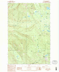
1988 Map of White Pass
USGS Topo · Published 1988About this map
The Pacific Crest National Scenic Trail winds through the heart of the Cascades in this 1980s survey, marking a corridor where the William O Douglas Wilderness meets the Gifford Pinchot National Forest. This high-altitude landscape is defined by its water system, with the Clear Fork Cowlitz River and Cowlitz River draining numerous alpine basins. Historically significant waypoints like Soda Springs and Log Spring indicate early natural landmarks for travelers crossing Cowlitz Pass. The map captures the meeting of several protected areas, including the Goat Rocks Wilderness and Snoqualmie National Forest, illustrating a complex network of trails and wilderness boundaries near the White Pass Campground at the Yakima and Lewis County line.
Find a feature on this map
46 named features on this map. Tap any name to fly to it.
Don’t see what you’re looking for? This feature index may not catch every label — zoom into the map to look around manually.
Map Details
Editions of this 1988 White Pass Map
2 editions found
Other maps of this area

1902 · Mount Aix
USGS Topo · 1:125,000

1904 · Mt Aix
USGS Topo · 1:125,000

1924 · Mt Rainier
USGS Topo · 1:96,000

1928 · Mt Rainier
USGS Topo · 1:125,000

1950 · Yakima
USGS Topo · 1:250,000

1958 · Yakima
USGS Topo · 1:250,000

1961 · Yakima
USGS Topo · 1:250,000

1962 · Bumping Lake
USGS Topo · 1:62,500

1962 · White Pass
USGS Topo · 1:62,500

1962 · Packwood
USGS Topo · 1:62,500