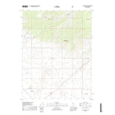
2018 Map of White Pine Peak
USGS Topo · Published 2018About this map
White Pine Peak serves as a prominent high point within the White Pine Range, where the high-altitude terrain of the Humboldt National Forest drops sharply toward the desert floor of Railroad Valley. This landscape is defined by its scarce water sources and the transition between timbered slopes and arid basins. Vital hydrology is marked by isolated features like Crystal Spring, Silver Spring, and Angle-Worm Spring, which historically supported livestock and wildlife in this portion of Nye County. The lower elevations show the footprint of local water management at Manzonie Reservoir, which captures drainage from Currant Cr. Remote access points such as Angleworm Rd and Brook Ln provide the only infrastructure through these alluvial fans, reflecting the region's enduring character as an open grazing and wilderness territory.
Find a feature on this map
19 named features on this map. Tap any name to fly to it.
Don’t see what you’re looking for? This feature index may not catch every label — zoom into the map to look around manually.
Map Details
Editions of this 2018 White Pine Peak Map
This is the sole edition of this map. No revisions or reprints were ever made.
Other maps of this area

1956 · Lund
USGS Topo · 1:250,000

1957 · Currant Mtn
USGS Topo · 1:62,500

1960 · Lund
USGS Topo · 1:250,000

1964 · Blue Eagle Springs
USGS Topo · 1:62,500

1964 · Duckwater
USGS Topo · 1:62,500

1964 · Currant
USGS Topo · 1:62,500

1964 · Currant Mtn
USGS Topo · 1:62,500

1980 · Duckwater
USGS Topo · 1:100,000
1990 · Duckwater NE
USGS Topo · 1:24,000
1990 · Currant
USGS Topo · 1:24,000