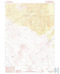
1990 Map of White Pine Peak
USGS Topo · Published 1990About this map
White Pine Peak dominates the northern terrain of this quadrangle, situated within the eastern reaches of the Humboldt National Forest. This high-elevation landscape transitions south into the White Pine Range and Horse Range, where the steep topography gives way to the broad alluvial plains of Railroad Valley. Water sources are sparse but critical in this arid region, marked by Silver Spring and Crystal Spring, while Currant Creek drains the southern slopes. Human activity is evidenced by the isolated Angleworm Ranch and small-scale resource extraction. Scattered labels for a Mine, Prospect, and Gravel Pit suggest localized exploration and maintenance along the unimproved roads that snake through the canyons and across the valley floor.
Find a feature on this map
14 named features on this map. Tap any name to fly to it.
Don’t see what you’re looking for? This feature index may not catch every label — zoom into the map to look around manually.
Map Details
Editions of this 1990 White Pine Peak Map
This is the sole edition of this map. No revisions or reprints were ever made.
Other maps of this area

1956 · Lund
USGS Topo · 1:250,000

1957 · Currant Mtn
USGS Topo · 1:62,500

1960 · Lund
USGS Topo · 1:250,000

1964 · Blue Eagle Springs
USGS Topo · 1:62,500

1964 · Duckwater
USGS Topo · 1:62,500

1964 · Currant
USGS Topo · 1:62,500

1964 · Currant Mtn
USGS Topo · 1:62,500

1980 · Duckwater
USGS Topo · 1:100,000
1990 · Duckwater NE
USGS Topo · 1:24,000
1990 · Currant
USGS Topo · 1:24,000