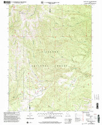
2001 Map of White Pine Peak
USGS Topo · Published 2003About this map
White Pine Peak serves as a dominant high point in this 2001 revision of the mountainous terrain along the Millard and Sevier county line. Located within the Fishlake National Forest, the landscape is defined by a complex drainage system where White Pine Creek and Bear Creek flow from the high slopes. The presence of a Substation and Communication Tower near the peak suggests the area's role as a modern utility and signal corridor, despite the otherwise undeveloped wilderness character of the terrain.
Find a feature on this map
26 named features on this map. Tap any name to fly to it.
Don’t see what you’re looking for? This feature index may not catch every label — zoom into the map to look around manually.
Map Details
Editions of this 2001 White Pine Peak Map
This is the sole edition of this map. No revisions or reprints were ever made.
Other maps of this area

1885 · Beaver
USGS Topo · 1:250,000

1932 · Sevier
USGS Topo · 1:62,500

1935 · Sevier
USGS Topo · 1:62,500

1940 · Monroe
USGS Topo · 1:62,500

1944 · Monroe
USGS Topo · 1:62,500

1953 · Richfield
USGS Topo · 1:250,000

1958 · Richfield
USGS Topo · 1:250,000

1961 · Fillmore
USGS Topo · 1:24,000

1961 · Mt. Catherine
USGS Topo · 1:24,000

1961 · Richfield
USGS Topo · 1:62,500