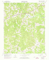
1963 Map of White Plains
USGS Topo · Published 1974About this map
The Meherrin River meanders across the northern portion of this Southside Virginia landscape, serving as a primary geographic anchor for the rural communities of Brunswick County. In the early 1960s, the area was characterized by a dense network of small settlements and family-named corners such as Gholsonville, Merchant, and Diamond Grove. The presence of Hicks Mill along the waterway suggests the enduring importance of local industry and river-based commerce in this region.
Find a feature on this map
42 named features on this map. Tap any name to fly to it.
Don’t see what you’re looking for? This feature index may not catch every label — zoom into the map to look around manually.
Map Details
Editions of this 1963 White Plains Map
2 editions found

Other maps of this area

1918 · Lawrenceville
USGS Topo · 1:62,500

1919 · White Plains
USGS Topo · 1:48,000

1920 · Lawrenceville
USGS Topo · 1:48,000

1920 · White Plains
USGS Topo · 1:62,500

1921 · Lawrenceville
USGS Topo · 1:62,500

1942 · Lawrenceville
USGS Topo · 1:62,500

1953 · Norfolk
USGS Topo · 1:250,000

1953 · Greensboro
USGS Topo · 1:250,000

1954 · Greensboro
USGS Topo · 1:250,000

1955 · Kenbridge
USGS Topo · 1:62,500