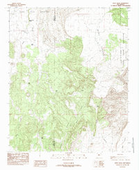
1985 Map of White Ridge
USGS Topo · Published 1985About this map
Laguna Indian Reservation lands dominate this mid-1980s landscape, where the high plateau of Mesa Lucero drops toward the Antonio Sedillo Grant Boundary. The terrain is defined by its drainages and critical water sources, including Lower Water Spring and Lucero Spring nestled near the steep escarpments. The prominence of White Ridge and the Sierra highlight a complex geological profile, while the presence of scattered livestock infrastructure like Willie Tank, Click Tank, and Tank No 4 suggests a continuing history of high-desert ranching. This provisional survey captures the intersection of tribal land management and New Mexico's land grant history, marked by the winding paths of Arroyo Lucero and Arroyo Comanche that carve through the mesa country.
Find a feature on this map
16 named features on this map. Tap any name to fly to it.
Don’t see what you’re looking for? This feature index may not catch every label — zoom into the map to look around manually.
Map Details
Editions of this 1985 White Ridge Map
This is the sole edition of this map. No revisions or reprints were ever made.
Other maps of this area

1917 · Cerro Verde
USGS Topo · 1:125,000

1954 · South Garcia
USGS Topo · 1:24,000

1954 · South Garcia SE
USGS Topo · 1:24,000

1954 · Socorro
USGS Topo · 1:250,000

1956 · South Garcia
USGS Topo · 1:62,500

1956 · Mesa Aparejo
USGS Topo · 1:62,500

1958 · Socorro
USGS Topo · 1:250,000
1960 · Dough Mountain
USGS Topo · 1:24,000

1960 · Cerro Verde
USGS Topo · 1:24,000

1962 · Socorro
USGS Topo · 1:250,000