
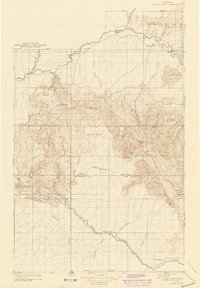
1910 Map of White River
USGS Topo · Published 1910About this map
The White River and Yampa River corridors define this northwest Colorado landscape as it appeared in the years following the 1907 survey. The territory is a network of high basins and plateaus, with the Routt Co Rio Blanco Co boundary line bisecting the central terrain. Settled outposts are few, centered on locations like Maybell P O and the Lily settlement at the confluence of the Little Snake River.
Find a feature on this map
51 named features on this map. Tap any name to fly to it.
Don’t see what you’re looking for? This feature index may not catch every label — zoom into the map to look around manually.
Map Details
Editions of this 1910 White River Map
2 editions found
Other maps of this area

1906 · Grand Hogback
USGS Topo · 1:125,000

1907 · Rangely
USGS Topo · 1:125,000

1907 · White River
USGS Topo · 1:125,000

1910 · Danforth Hills
USGS Topo · 1:125,000

1910 · Grand Hogback
USGS Topo · 1:125,000

1910 · Rangely
USGS Topo · 1:125,000

1912 · Meeker
USGS Topo · 1:62,500

1912 · Axial
USGS Topo · 1:62,500

1914 · Meeker
USGS Topo · 1:62,500

1914 · Axial
USGS Topo · 1:62,500