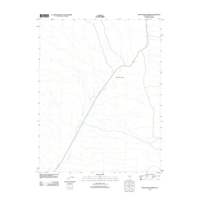
2012 Map of White River Narrows
USGS Topo · Published 2012About this map
The White River Narrows pass through a corridor of Lincoln County, defined by a dramatic north-south drainage system in the high desert. This 2012 survey shows the White River as it winds through the canyon landscape, punctuated by the Nesbitt Reservoir. The infrastructure is sparse, characterized by a primary roadway that follows the path of the river, highlighting how the narrow topographical features of the basin dictated the route of travel and water management in this arid part of Nevada. While the surrounding terrain is marked by intricate drainage patterns, the core of the area is centered on these vital water resources and the natural pass through the rock.
Find a feature on this map
3 named features on this map. Tap any name to fly to it.
Don’t see what you’re looking for? This feature index may not catch every label — zoom into the map to look around manually.
Map Details
Editions of this 2012 White River Narrows Map
This is the sole edition of this map. No revisions or reprints were ever made.
Other maps of this area

1885 · Pioche
USGS Topo · 1:250,000

1886 · Pioche
USGS Topo · 1:250,000

1954 · Caliente
USGS Topo · 1:250,000

1959 · Caliente
USGS Topo · 1:250,000

1970 · Hiko NE
USGS Topo · 1:24,000

1970 · Oreana Spring
USGS Topo · 1:24,000

1970 · Seaman Wash
USGS Topo · 1:24,000
1970 · Deadman Spring
USGS Topo · 1:24,000

1970 · Wheatgrass Spring
USGS Topo · 1:24,000

1970 · Fossil Peak
USGS Topo · 1:24,000