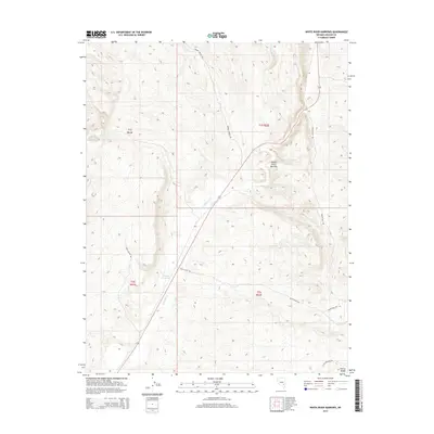
2014 Map of White River Narrows
USGS Topo · Published 2014About this map
The White River Narrows create a distinct geological corridor through this portion of the Pahroc Range in Lincoln County. The White River flows southward through the center of the sheet, feeding into the Nesbitt Reservoir, which serves as a vital water source in this arid landscape. The map details a network of rural routes that provide access to the backcountry, including Weepah Springs Rd, Water Hall Rd, and Little Boulder Rd. These roads often follow natural drainage patterns and canyon floors, such as Louis Canyon, illustrating how the desert topography dictates movement and land use. This 2014 survey documents the modern state of these traditional travel ways and water management features within the public land survey system of Nevada.
Find a feature on this map
13 named features on this map. Tap any name to fly to it.
Don’t see what you’re looking for? This feature index may not catch every label — zoom into the map to look around manually.
Map Details
Editions of this 2014 White River Narrows Map
This is the sole edition of this map. No revisions or reprints were ever made.
Other maps of this area

1885 · Pioche
USGS Topo · 1:250,000

1886 · Pioche
USGS Topo · 1:250,000

1954 · Caliente
USGS Topo · 1:250,000

1959 · Caliente
USGS Topo · 1:250,000

1970 · Hiko NE
USGS Topo · 1:24,000

1970 · Oreana Spring
USGS Topo · 1:24,000

1970 · Seaman Wash
USGS Topo · 1:24,000
1970 · Deadman Spring
USGS Topo · 1:24,000

1970 · Wheatgrass Spring
USGS Topo · 1:24,000

1970 · Fossil Peak
USGS Topo · 1:24,000