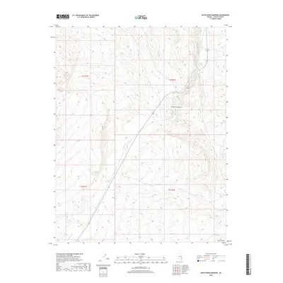
2018 Map of White River Narrows
USGS Topo · Published 2018About this map
White River Narrows defines the central topography of this Lincoln County survey, where the intermittent channel of the White River winds through a high-elevation corridor. This 2018 mapping captures the drainage patterns south of the Hiko area, showcasing the desert basin's hydrologic features such as Nesbitt Reservoir. The terrain is bounded to the southeast by the rising slopes of the Pahroc Range, a significant volcanic mountain chain characteristic of the Great Basin's north-south mountain structures. State Route 318 follows the river valley, serving as a primary transit artery through the public lands and range allotments of the eastern Nevada desert. The map provides clear detail of the Public Land Survey System grid, indicating township and range boundaries that govern this expansive landscape.
Find a feature on this map
9 named features on this map. Tap any name to fly to it.
Don’t see what you’re looking for? This feature index may not catch every label — zoom into the map to look around manually.
Map Details
Editions of this 2018 White River Narrows Map
This is the sole edition of this map. No revisions or reprints were ever made.
Other maps of this area

1885 · Pioche
USGS Topo · 1:250,000

1886 · Pioche
USGS Topo · 1:250,000

1954 · Caliente
USGS Topo · 1:250,000

1959 · Caliente
USGS Topo · 1:250,000

1970 · Hiko NE
USGS Topo · 1:24,000

1970 · Oreana Spring
USGS Topo · 1:24,000

1970 · Seaman Wash
USGS Topo · 1:24,000
1970 · Deadman Spring
USGS Topo · 1:24,000

1970 · Wheatgrass Spring
USGS Topo · 1:24,000

1970 · Fossil Peak
USGS Topo · 1:24,000