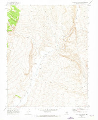
1970 Map of White River Narrows
USGS Topo · Published 1973About this map
White River Narrows serves as the focal point of this arid landscape in Lincoln County, Nevada, where the desert canyon floor is punctuated by evidence of early inhabitants and modern resource extraction. The 1970 field check identifies several sites marked as Petroglyphs, indicating the long-standing archaeological importance of these rocky corridors. The White River flows southward through the basin, flanked by a network of Jeep Trails that negotiate the broken terrain. Human activity is sparse but distinct, shown by a Borrow Pit and a lone Well located in the southern flats. This mapping, derived from 1969 aerial photography, documents the transition of the Great Basin terrain before increased modern recreational access changed the character of these remote desert canyons.
Find a feature on this map
6 named features on this map. Tap any name to fly to it.
Don’t see what you’re looking for? This feature index may not catch every label — zoom into the map to look around manually.
Map Details
Editions of this 1970 White River Narrows Map
This is the sole edition of this map. No revisions or reprints were ever made.
Other maps of this area

1885 · Pioche
USGS Topo · 1:250,000

1886 · Pioche
USGS Topo · 1:250,000

1954 · Caliente
USGS Topo · 1:250,000

1959 · Caliente
USGS Topo · 1:250,000

1970 · Hiko NE
USGS Topo · 1:24,000

1970 · Oreana Spring
USGS Topo · 1:24,000

1970 · Seaman Wash
USGS Topo · 1:24,000
1970 · Deadman Spring
USGS Topo · 1:24,000

1970 · Wheatgrass Spring
USGS Topo · 1:24,000

1970 · Fossil Peak
USGS Topo · 1:24,000