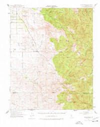
1952 Map of White River
USGS Topo · Published 1978About this map
Deer Creek Colony and Ultra occupy the western edge of this 1952 topographic study, where the flat valley floor meets the rising foothills of the Sierra Nevada. The historical Los Angeles Stage Road winds across the Tennessee Ridge and through Fountain Springs, marking a vital transportation corridor before modern highways redirected regional traffic. To the east, the landscape becomes significantly more complex, encompassing the rugged heights of Buck Peak and the Tule River Indian Reservation.
Find a feature on this map
53 named features on this map. Tap any name to fly to it.
Don’t see what you’re looking for? This feature index may not catch every label — zoom into the map to look around manually.
Map Details
Editions of this 1952 White River Map
4 editions found
Other maps of this area

1904 · Kaweah
USGS Topo · 1:125,000

1909 · Kaweah
USGS Topo · 1:125,000

1920 · Delonagha
USGS Topo · 1:62,500

1926 · Quincy School
USGS Topo · 1:31,680

1926 · Glennville
USGS Topo · 1:62,500

1929 · Richgrove
USGS Topo · 1:31,680

1929 · Porterville
USGS Topo · 1:31,680

1929 · Quincy School
USGS Topo · 1:31,680

1929 · Ducor
USGS Topo · 1:31,680

1931 · Deepwell Ranch
USGS Topo · 1:31,680