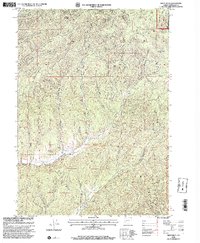
1998 Map of White Rock
USGS Topo · Published 2000About this map
Chieftain Mine and the Continental Mine anchor this high-elevation landscape in Douglas County, representing the legacy of resource extraction within the eastern Cascades. This late-twentieth-century revision by the USDA Forest Service highlights a rugged drainage system where North Myrtle Creek and South Myrtle Creek carve deep valleys between prominent features like Buck Butte and Riser Butte. The terrain is characterized by its dense network of waterways, including Weaver Creek and Letitia Creek, which flow through the protected boundaries of the Umpqua National Forest. Evidence of land use is visible in the placement of a Quarry and a Weir along the creek beds, while seasonal water sources such as White Rock Spring and Yellow Jacket Spring suggest the specific locations of remote high-country camps and watering holes.
Find a feature on this map
26 named features on this map. Tap any name to fly to it.
Don’t see what you’re looking for? This feature index may not catch every label — zoom into the map to look around manually.
Map Details
Editions of this 1998 White Rock Map
This is the sole edition of this map. No revisions or reprints were ever made.
Other maps of this area

1891 · Ashland
USGS Topo · 1:250,000

1893 · Ashland
USGS Topo · 1:250,000

1897 · Roseburg
USGS Topo · 1:125,000

1897 · Ashland
USGS Topo · 1:250,000

1900 · Roseburg
USGS Topo · 1:125,000

1904 · Riddle
USGS Topo · 1:125,000

1944 · Tiller
USGS Topo · 1:62,500

1954 · Dixonville
USGS Topo · 1:62,500

1954 · Days Creek
USGS Topo · 1:62,500

1955 · Red Butte
USGS Topo · 1:62,500