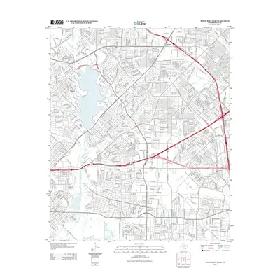
2012 Map of White Rock Lake
USGS Topo · Published 2012About this map
White Rock Lake dominates this portion of Dallas, serving as a central hub for the surrounding neighborhoods and the extensive shoreline roads of W Lawther Dr and E Lawther Dr. The 2012 survey illustrates a densely developed urban and suburban landscape, where older community footprints like Rawlins and Reinhardt have integrated into the modern metropolitan fabric. The eastern side of the map highlights a massive transportation network, including the complex interchanges of the E R L Thornton Fwy and N Sam Houston Rd. Educational and specialized institutions such as Eastfield Coll and the Dallas Institute Of Funeral Service are prominent features alongside residential developments. Several waterways, including White Rock Cr, Jackson Br, and Dixon Br, cut through the terrain, maintaining the area's original drainage patterns despite the surrounding urban expansion.
Find a feature on this map
49 named features on this map. Tap any name to fly to it.
Don’t see what you’re looking for? This feature index may not catch every label — zoom into the map to look around manually.
Map Details
Editions of this 2012 White Rock Lake Map
This is the sole edition of this map. No revisions or reprints were ever made.
Other maps of this area

1891 · Dallas
USGS Topo · 1:125,000

1893 · Dallas
USGS Topo · 1:125,000

1931 · Carrollton
USGS Topo · 1:62,500

1954 · Dallas
USGS Topo · 1:250,000

1957 · White Rock Lake
USGS Topo · 1:24,000

1958 · Dallas
USGS Topo · 1:250,000

1958 · Hutchins
USGS Topo · 1:24,000

1958 · Oak Cliff
USGS Topo · 1:24,000

1958 · Dallas
USGS Topo · 1:24,000

1958 · White Rock Lake
USGS Topo · 1:24,000