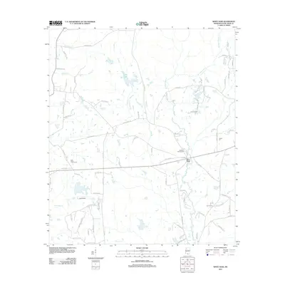
2012 Map of White Sand
USGS Topo · Published 2012About this map
White Sand serves as a central point in this rural Mississippi landscape, situated along a network of creek drainages including W Hobolochitto Cr and Chinquapin Cr. The terrain is defined by a dense web of local roads named for established families, such as Adolph Parker Rd and H K Sones Rd, reflecting the area's deep-rooted land ownership. Agricultural and utilitarian land use is evident through features like Egg Farm Rd and the Buck Branch Lookout Tower, which once provided a vantage point over the surrounding timberlands.
Find a feature on this map
82 named features on this map. Tap any name to fly to it.
Don’t see what you’re looking for? This feature index may not catch every label — zoom into the map to look around manually.
Map Details
Editions of this 2012 White Sand Map
This is the sole edition of this map. No revisions or reprints were ever made.
Other maps of this area

1942 · Pools Bluff
USGS Topo · 1:31,680

1949 · Bogalusa East
USGS Topo · 1:31,680

1949 · Angie
USGS Topo · 1:31,680

1953 · Mobile
USGS Topo · 1:250,000

1957 · Mobile
USGS Topo · 1:250,000

1958 · Picayune
USGS Topo · 1:62,500

1959 · Bogalusa
USGS Topo · 1:62,500

1959 · Poplarville
USGS Topo · 1:62,500

1960 · Mobile
USGS Topo · 1:250,000
1961 · Sun
USGS Topo · 1:62,500