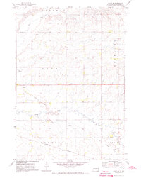
1972 Map of White SE
USGS Topo · Published 1973About this map
Sherman, Alton, and Richland townships converge in this agricultural landscape of Brookings County, shaped by the drainage of Deer Creek and Medary Creek. The map documents a period of changing transportation infrastructure, most notably the path of the Old Railroad Grade cutting across the central sections. Farther south, the Chicago and North Western corridor remains a prominent landmark through Parnell and Elkton.
Find a feature on this map
10 named features on this map. Tap any name to fly to it.
Don’t see what you’re looking for? This feature index may not catch every label — zoom into the map to look around manually.
Map Details
Editions of this 1972 White SE Map
This is the sole edition of this map. No revisions or reprints were ever made.
Other maps of this area

1953 · Watertown
USGS Topo · 1:250,000

1958 · Watertown
USGS Topo · 1:250,000

1964 · Flandreau NW
USGS Topo · 1:24,000

1964 · Aurora
USGS Topo · 1:24,000

1967 · Lake Benton NW
USGS Topo · 1:24,000

1967 · Lake Benton SW
USGS Topo · 1:24,000

1967 · Elkton
USGS Topo · 1:24,000

1970 · White NE
USGS Topo · 1:24,000

1970 · White
USGS Topo · 1:24,000

1972 · Flandreau NE
USGS Topo · 1:24,000
Featured Places
- Elkton Township, SD
- Sherman Township, SD
- Parnell Township, SD
- Rolland Hutterite Colony, SD
- Alton Township, SD