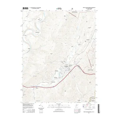
2014 Map of White Sulphur Springs
USGS Topo · Published 2014About this map
White Sulphur Springs serves as the focal point of this 2014 survey, highlighting the area's legacy as a world-class destination for mineral springs and recreation. The map details the extensive grounds of The Greenbrier Resort Golf Course, along with the White Sulphur Spring and White Sulphur Chalybeate Spring. Beyond the resort, the landscape is defined by the Greenbrier River as it winds past small communities like Loopemount and Keister. To the east, the boundary between Greenbrier County and Alleghany County follows the high ridges of the Monongahela National Forest. Significant infrastructure is documented, including the National Fish Hatchery and the Allegheny Tunnel near Tuckahoe, where the terrain transitions into West Virginia-Virginia. The survey provides a clear view of the complex road networks, such as Us-60 and Midland Trail, that connect these mountain settlements.
Find a feature on this map
82 named features on this map. Tap any name to fly to it.
Don’t see what you’re looking for? This feature index may not catch every label — zoom into the map to look around manually.
Map Details
Editions of this 2014 White Sulphur Springs Map
This is the sole edition of this map. No revisions or reprints were ever made.
Other maps of this area

1887 · Lewisburg
USGS Topo · 1:125,000

1891 · Lewisburg
USGS Topo · 1:125,000

1921 · Callaghan
USGS Topo · 1:48,000

1921 · White Sulphur Springs
USGS Topo · 1:48,000

1921 · Ronceverte
USGS Topo · 1:48,000

1923 · White Sulphur Springs
USGS Topo · 1:62,500

1923 · Ronceverte
USGS Topo · 1:62,500

1923 · Callaghan
USGS Topo · 1:62,500

1935 · White Sulphur Springs
USGS Topo · 1:62,500

1939 · White Sulphur Springs
USGS Topo · 1:62,500