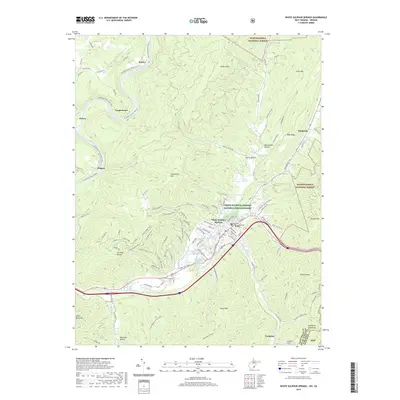
2019 Map of White Sulphur Springs
USGS Topo · Published 2019About this map
White Sulphur Springs serves as the focal point of this survey, where the historic spa culture of the Allegheny Mountains is grounded in the presence of the White Sulphur Spring and White Sulphur Chalybeate Spring. The landscape transitions from the developed resort and municipal corridors to the dense woodlands of the Monongahela National Forest, marked by numerous ridges such as Kates Mtn and Coles Mtn. Modern conservation and recreation are represented by the White Sulphur Springs National Fish Hatchery and the Greenbrier River Rail-Trail, the latter following the winding course of the Greenbrier River past settlements like Loopemount and Keister. The map documents a sophisticated network of forest trails, including the Raven Rock Trail and Turkey-Hollow Trail, illustrating the area's dual identity as a center for both mineral spring tourism and rugged mountain recreation.
Find a feature on this map
120 named features on this map. Tap any name to fly to it.
Don’t see what you’re looking for? This feature index may not catch every label — zoom into the map to look around manually.
Map Details
Editions of this 2019 White Sulphur Springs Map
This is the sole edition of this map. No revisions or reprints were ever made.
Other maps of this area

1887 · Lewisburg
USGS Topo · 1:125,000

1891 · Lewisburg
USGS Topo · 1:125,000

1921 · Callaghan
USGS Topo · 1:48,000

1921 · White Sulphur Springs
USGS Topo · 1:48,000

1921 · Ronceverte
USGS Topo · 1:48,000

1923 · White Sulphur Springs
USGS Topo · 1:62,500

1923 · Ronceverte
USGS Topo · 1:62,500

1923 · Callaghan
USGS Topo · 1:62,500

1935 · White Sulphur Springs
USGS Topo · 1:62,500

1939 · White Sulphur Springs
USGS Topo · 1:62,500