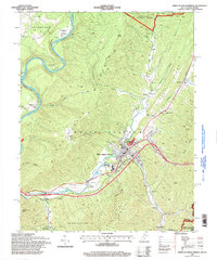
1995 Map of White Sulphur Springs
USGS Topo · Published 1998About this map
White Sulphur Springs serves as the primary hub in this portion of the Allegheny Mountains, where the landscape transitions from the protected timberlands of Monongahela National Forest and Greenbrier State Forest to the developed valley floors. The town's reputation as a destination is reflected in the multiple Golf Course layouts and the Greenbrier Airport along Howard Creek. To the north, the Greenbrier River carves a deep loop around Loopemount and Keister, following a path through Frankford.
Find a feature on this map
51 named features on this map. Tap any name to fly to it.
Don’t see what you’re looking for? This feature index may not catch every label — zoom into the map to look around manually.
Map Details
Editions of this 1995 White Sulphur Springs Map
This is the sole edition of this map. No revisions or reprints were ever made.
Other maps of this area

1887 · Lewisburg
USGS Topo · 1:125,000

1891 · Lewisburg
USGS Topo · 1:125,000

1921 · Callaghan
USGS Topo · 1:48,000

1921 · White Sulphur Springs
USGS Topo · 1:48,000

1921 · Ronceverte
USGS Topo · 1:48,000

1923 · White Sulphur Springs
USGS Topo · 1:62,500

1923 · Ronceverte
USGS Topo · 1:62,500

1923 · Callaghan
USGS Topo · 1:62,500

1935 · White Sulphur Springs
USGS Topo · 1:62,500

1939 · White Sulphur Springs
USGS Topo · 1:62,500