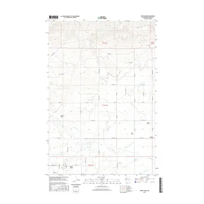
2017 Map of White Swan
USGS Topo · Published 2017About this map
White Swan serves as the central hub for this portion of the Yakama Reservation, where the flatlands of Medicine Valley and Yakima Valley meet. The landscape is defined by an intricate network of irrigation channels, including the Barney Pacific Lateral, Indian Lateral, and Ayres Lateral, which distribute water from Simcoe Cr and Toppenish Cr across the agricultural basin. These man-made waterways underscore the region's reliance on managed water systems to sustain its valley farms.
Find a feature on this map
55 named features on this map. Tap any name to fly to it.
Don’t see what you’re looking for? This feature index may not catch every label — zoom into the map to look around manually.
Map Details
Editions of this 2017 White Swan Map
This is the sole edition of this map. No revisions or reprints were ever made.
Other maps of this area

1899 · Ellensburg
USGS Topo · 1:125,000

1901 · Ellensburg
USGS Topo · 1:125,000

1937 · White Swan
USGS Topo · 1:125,000

1950 · Yakima
USGS Topo · 1:250,000

1958 · Toppenish Mtn.
USGS Topo · 1:24,000

1958 · Harrah
USGS Topo · 1:24,000
1958 · Yakima West
USGS Topo · 1:24,000

1958 · Fort Simcoe
USGS Topo · 1:24,000

1958 · Fort Simcoe
USGS Topo · 1:62,500

1958 · Wiley City
USGS Topo · 1:24,000