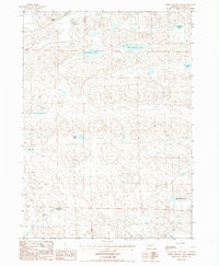
1987 Map of White Willow Lake
USGS Topo · Published 1987About this map
White Willow Lake lies at the heart of this Sandhills landscape in Cherry County, where the topography is defined by the unique hydrology of Nebraska's perched water tables. The map documents a sparse ranching environment in the late 1980s, anchored by established family operations like the Pullman Ranch in the north and the Phipps Ranch near the southern border. This region is characterized by an absence of paved thoroughfares, with navigation relying entirely on a network of 4wd trails that snake between the dunes and depressions.
Find a feature on this map
14 named features on this map. Tap any name to fly to it.
Don’t see what you’re looking for? This feature index may not catch every label — zoom into the map to look around manually.
Map Details
Editions of this 1987 White Willow Lake Map
This is the sole edition of this map. No revisions or reprints were ever made.
Other maps of this area

1948 · Whitman
USGS Topo · 1:62,500

1949 · Steverson Lake
USGS Topo · 1:62,500

1950 · Whitman
USGS Topo · 1:62,500

1950 · Hire
USGS Topo · 1:62,500

1950 · Wolf Lake
USGS Topo · 1:62,500

1951 · Steverson Lake
USGS Topo · 1:62,500

1951 · Wolf Lake
USGS Topo · 1:62,500

1957 · Valentine
USGS Topo · 1:250,000

1959 · Valentine
USGS Topo · 1:250,000

1985 · Mullen
USGS Topo · 1:100,000