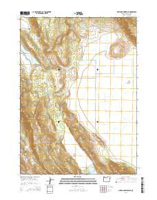
2014 Map of Whiteline Reservoir
USGS Topo · Published 2014About this map
Antelope Valley and Swan Lake Valley define the high-desert landscape of this southern Oregon survey, where water sources are vital markers on the land. Named springs such as Janssen Spring, Cold Spring, and Brookside Spring illustrate the historic importance of reliable water for ranching and settlement. The map highlights the localized geography of the Cascades' eastern slopes, featuring prominent elevations like Twomile Ridge, Grizzly Butte, and Hogback Mtn. For genealogists and local historians, the inclusion of the Gabriel Cem and Hibbert Cem provides specific burial sites linked to the area's early families. The drainage patterns of Anderson Cr and Janssen Spring Cr feed into reservoirs like Whiteline Reservoir, showing the transition from natural waterways to managed irrigation systems.
Find a feature on this map
38 named features on this map. Tap any name to fly to it.
Don’t see what you’re looking for? This feature index may not catch every label — zoom into the map to look around manually.
Map Details
Editions of this 2014 Whiteline Reservoir Map
This is the sole edition of this map. No revisions or reprints were ever made.
Other maps of this area

1889 · Klamath
USGS Topo · 1:250,000

1894 · Klamath
USGS Topo · 1:250,000

1955 · Klamath Falls
USGS Topo · 1:250,000

1957 · Merrill
USGS Topo · 1:62,500

1957 · Swan Lake
USGS Topo · 1:62,500

1957 · Klamath Falls
USGS Topo · 1:62,500

1957 · Modoc Point
USGS Topo · 1:62,500

1958 · Klamath Falls
USGS Topo · 1:250,000
1975 · Klamath Falls NE
USGS Topo · 1:24,000

1975 · Merrill NW
USGS Topo · 1:24,000