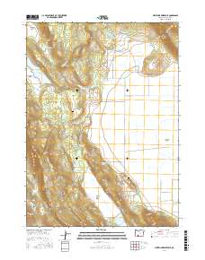
2017 Map of Whiteline Reservoir
USGS Topo · Published 2017About this map
Swan Lake Valley dominates the eastern half of this landscape northeast of Klamath Falls, where the high-desert terrain of Klamath County is defined by a series of volcanic buttes and seasonal water sources. The map details an area characterized by significant elevation changes, from the heights of Hogback Mtn and Grizzly Butte down to the expansive floor of Antelope Valley. Water management is central to this environment, evidenced by the Whiteline Reservoir, Oberman Reservoir, and numerous named springs like Surveyors Spring and Chitwood Spring that sustain the local livestock and wildlife.
Find a feature on this map
38 named features on this map. Tap any name to fly to it.
Don’t see what you’re looking for? This feature index may not catch every label — zoom into the map to look around manually.
Map Details
Editions of this 2017 Whiteline Reservoir Map
This is the sole edition of this map. No revisions or reprints were ever made.
Other maps of this area

1889 · Klamath
USGS Topo · 1:250,000

1894 · Klamath
USGS Topo · 1:250,000

1955 · Klamath Falls
USGS Topo · 1:250,000

1957 · Merrill
USGS Topo · 1:62,500

1957 · Swan Lake
USGS Topo · 1:62,500

1957 · Klamath Falls
USGS Topo · 1:62,500

1957 · Modoc Point
USGS Topo · 1:62,500

1958 · Klamath Falls
USGS Topo · 1:250,000
1975 · Klamath Falls NE
USGS Topo · 1:24,000

1975 · Merrill NW
USGS Topo · 1:24,000