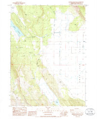
1985 Map of Whiteline Reservoir
USGS Topo · Published 1985About this map
Swan Lake Valley dominates this mid-1980s landscape, characterized by a complex network of springs and intermittent water bodies. The eastern portion of the map is defined by the Swan Lake Valley floor, including an extensive area subject to inundation and numerous spoil banks. To the west, the terrain rises sharply toward Hogback Mountain and Twomile Ridge, which overlook the blue waters of Whiteline Reservoir.
Find a feature on this map
30 named features on this map. Tap any name to fly to it.
Don’t see what you’re looking for? This feature index may not catch every label — zoom into the map to look around manually.
Map Details
Editions of this 1985 Whiteline Reservoir Map
This is the sole edition of this map. No revisions or reprints were ever made.
Other maps of this area

1889 · Klamath
USGS Topo · 1:250,000

1894 · Klamath
USGS Topo · 1:250,000

1955 · Klamath Falls
USGS Topo · 1:250,000

1957 · Merrill
USGS Topo · 1:62,500

1957 · Swan Lake
USGS Topo · 1:62,500

1957 · Klamath Falls
USGS Topo · 1:62,500

1957 · Modoc Point
USGS Topo · 1:62,500

1958 · Klamath Falls
USGS Topo · 1:250,000
1975 · Klamath Falls NE
USGS Topo · 1:24,000

1975 · Merrill NW
USGS Topo · 1:24,000